In an era where satellite imagery is becoming increasingly integral to various sectors, the ability to accurately reconstruct spatial maps from this data is more crucial than ever. A recent study introduces a groundbreaking deep learning methodology that leverages Graph Convolutional Networks (GCNs) to tackle the persistent challenges in building footprint reconstruction. This innovative approach, developed by researchers Muhammad Kamran, Mohammad Moein Sheikholeslami, Andreas Wichmann, and Gunho Sohn, promises to revolutionize the way we generate and update spatial maps of the built environment.
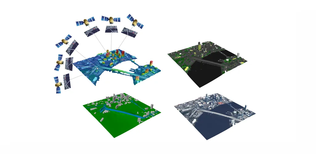
The proliferation of remote satellites orbiting the Earth has led to an unprecedented influx of high-resolution visual data. This data supports a wide array of applications, from civil and public sectors to military domains. Among these applications, the generation and updating of spatial maps have become particularly critical due to the extensive coverage and detailed imagery provided by satellites. However, reconstructing spatial maps from satellite imagery is a complex task that requires the creation of high-level object representations, such as primitives, to accurately capture the built environment. Despite significant advancements in object detection and representation using visual data over the past decade, primitives-based object representation remains a formidable challenge in computer vision. As a result, high-quality spatial maps often rely on labor-intensive and manual processes.
The research introduces a novel deep learning methodology that leverages Graph Convolutional Networks (GCNs) to address these challenges. The proposed approach enhances performance by incorporating geometric regularity into building boundaries, integrating multi-scale and multi-resolution features, and embedding Attraction Field Maps into the network. These innovations provide a scalable and precise solution for automated building footprint extraction from a single satellite image. The model, named Decoupled-PolyGCN, outperforms existing methods by 6% in Average Precision (AP) and 10% in Average Recall (AR), demonstrating its ability to deliver accurate and regularized building footprints across diverse and challenging scenarios.
The implications of this research are far-reaching. By automating the process of building footprint extraction, the Decoupled-PolyGCN model can significantly reduce the time and effort required for map generation and updating. This advancement is particularly impactful in urban planning, where accurate and up-to-date spatial maps are essential for effective decision-making. Additionally, the model’s ability to provide precise building footprints can enhance disaster management efforts by enabling rapid assessment of affected areas and facilitating more effective response strategies.
Furthermore, the model’s scalability makes it suitable for large-scale spatial analysis, allowing researchers and policymakers to gain insights into urban development trends, population density, and infrastructure needs. The ability to extract building footprints accurately from a single satellite image also opens up new possibilities for applications in environmental monitoring, where changes in land use and urban sprawl can be tracked over time.
The research highlights the potential of deep learning and GCNs in addressing longstanding challenges in computer vision and spatial mapping. By incorporating geometric regularity and multi-scale features, the Decoupled-PolyGCN model sets a new standard for accuracy and efficiency in building footprint reconstruction. As the demand for high-resolution satellite imagery continues to grow, the need for advanced techniques to process and analyze this data will become even more critical. The methodology proposed in this study represents a significant step forward in meeting this need, paving the way for impactful applications in various fields.
In conclusion, the introduction of the Decoupled-PolyGCN model marks a significant milestone in the field of spatial mapping and computer vision. By leveraging the power of deep learning and GCNs, the researchers have developed a solution that not only enhances the accuracy of building footprint reconstruction but also reduces the reliance on labor-intensive processes. The potential applications of this technology are vast, ranging from urban planning and disaster management to environmental monitoring. As we continue to explore the capabilities of advanced technologies, the insights gained from this research will undoubtedly play a crucial role in shaping the future of spatial analysis and urban development. Read the original research paper here.